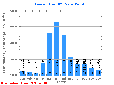
PEACE RIVER AT PEACE POINT
Mackenzie
Point ID:
801
Downloads
|
Plots
|
Site Data
Code:
07KC001
Latitude:
59.11°
Distance to Outlet:
N/A
Longitude:
-112.42°
Yearly Min:
1959
X EASE-Grid:
-3136981.00
Yearly Max:
2000
Y EASE-Grid:
1294252.00
Number of Years:
42
Drainage Area:
293000.00 km
2
Percentage of Coverage:
100%
Drainage Area Effective:
293000.00 km
2
Percentage of Coverage by Month:
99%
Source:
Hydat
Notes:
Gauge Altitude:
N/A
Field Definitions
Download
Site Descriptor Information
Site Time Series Data
Link to all available data
Site Data:
View:
Statistics
Time Series
All
Units:
mm
m
3
/s
Summary Statistics
Statistic
Jan
Feb
Mar
Apr
May
Jun
Jul
Aug
Sep
Oct
Nov
Dec
Annual
Unable to open file ./Points/Stats801|title=_ms.txtfor reading!